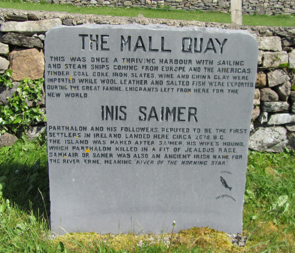
On leaving Enniskillen, we headed north on to Lower Lough Erne and moored on Devenish Island, on the West mooring. This is a T-shaped jetty, where there was room for us, as a broadbeam steel boat was just leaving. Two other cruisers arrived later on to join us on the mooring.
We walked up to see the ruins of St Mary’s Augustinian priory which was built in 1449. There were several different buildings and it was all in very good repair.
The Round Tower was very tall, and made me think of Rapunzel, sitting at the top window! We stayed on Devenish Island for two nights.
Although it was a little windy, we decided to set off. Now that we are on Lower Lough Erne, we are more restricted by the wind. The Puzzler goes through the waves well, as long as they are going the same way as us. We have to be careful to keep to the windward shore of the lough, wherever possible. It still seems a long way to the land as we pass Ardybeg point!
There are fewer large islands in the lower Lough, so the waves tend to build up more. We turned in behind Hay and Horse Islands into Rosslare bay. By the time we reached Inishclare harbour we were glad to be away from the white horses! This is a restaurant mooring, but it is closed on Monday and Tuesday, so it was very quiet.
Any closer to the wall outside the harbour and Sally would have been soaked by the
waves!
In the morning we sailed on, but pulled in to Rossigh mooring , a long jetty, to wait for the wind to abate. After lunch we set off again and had to go half way across the lough towards Owl Island, round marker 55J, in order to avoid the shallows.
The boat rolled a bit as we had to go broadside to the waves to make the turn.
Cruising on, we pass the red warning line on the charts. This states that “lake gets rough in strong winds north of this line”. We go on to the right, past Duross Point, and were glad to see the White Cairn marking the entrance to Castle Archdale harbour. This is a marina for private boats, but with a public jetty too. It is very sheltered.
A pleasant walk through the woods brought us to Castle Archdale, which was built in the 17th century. It was the station headquarters and officers billet of the wartime RAF base for Catalina and Sunderland aircraft. These were flying boats which went out into the Atlantic to combat German U-boats. There is a large caravan site on the old airfield below the castle.
The rhodedendrons are just starting to come into full bloom in the former gardens of Castle Archdale.
After staying overnight we sailed out on to the lough and briefly visited Davy’s Island, where some serious logging had been done. All the trees in the centre of this small island had been cut off at a height of 4 or 5 feet from the ground, presumably for timber. A ruined archway is really all that remains of an ancient church, but it is very neglected.
White Island, a little further on, is a complete contrast, with gleaming white stones on the ruins of the church. The White Island figures, mounted on an inner wall, are a unique group of 8 carved stones, which date from the 9th or 10th century.
We met the resident herd of cattle too, while exploring the island.
The weather improved during the day, so at 6pm we set off, going behind White Island, then taking the narrow channel behind Crevinishaughy and Cleenishgarve islands, to go round Gubbaroe Point on to the part of Lower Lough Erne, known as the Broad Lough.
The skies behind us were very threatening and it was pretty choppy, as we had to sail half a mile off shore, to avoid the rocks and small islands.
Catkin is getting very laid back about all these wide waters!
The goats seem very happy on Horse island, as we pass them. We are now going to the east towards Kesh River, and are sailing closer to the shore line.
We followed three pairs of markers, thinking we were heading for the Kesh River, and found a good jetty by a ruined castle. Pauline and Raymond came from their chalet to welcome us, and also to tell us that we were in fact now behind Rabbit Island, having turned off the lough more than two miles too soon! This is a new jetty, currently under development, and we stayed in this sheltered spot overnight.
Next morning we went back out round Rabbit Island and found another set of three markers, leading us in to Kesh River and so to Kesh village. The river is beautiful and is rather like a cross between the River Avon and the upper reaches of the River Thames, meandering through fields and wooded banks. There is just room to turn at Kesh, where the navigation ends at a weir under the town bridge.
We returned to the lough and sailed round the point to Mukros. Two men were swimming a horse there alongside the jetty. He did not seem too keen on this! There were three horses altogether, which were loaded into their horsebox, after cooling off.
This map shows the extent of Lower Lough Erne. Our journey tomorrow will take us the full length of the Broad Lough. We will sail from Mukros, which is near Kesh, in the east, to Castle Caldwell, which lies in the bay to the north of Belleek in the West.
At 6.30am on Saturday we set off down the Broad Lough, as the water was very calm. This did not last, however, and it became quite choppy, but not bad enough to turn back. We went to the inside of Lusty Beg Island, where it was very sheltered. After passing markers 61C3 and 61C4 it is a long, exposed run of three and a half miles straight along the North coast, just outside the shallow water markers. The cliffs of Magho, across the lough, are hidden by the mist.
The lough is then more sheltered as we pass several islands on the run in to Castle Caldwell mooring at the most north westerly part of the lough.
It is very pleasant walking in the woods on the Rossergole peninsula. The bluebells draw many walkers here, including friends, whom we had met at Keshgarrigan, and live nearby. They spotted us on the mooring, and came to visit.
The ruins of Castle Caldwell itself are completely overgrown with ivy.
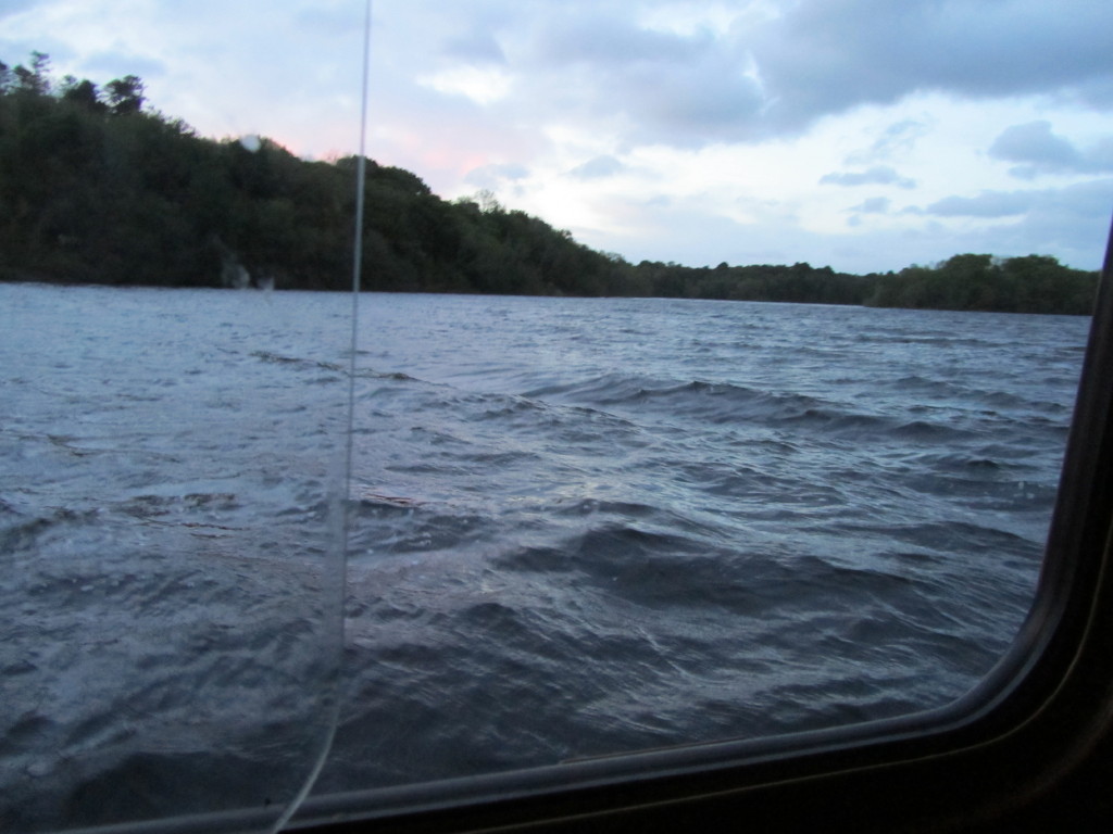
Later in the evening the wind changed and really pushed the waves into our bay, as seen through the boat window.
Catkin found the wind a bit too much!
On Monday we decided the lough was calm enough for the sail round Eagle Point and on down the River Erne to Belleek. However, on passing the islands leading to the main lough, the wind got up and it became too rough to continue. The turn was quite exciting, and can be compared to riding a bucking horse in slow motion! We were glad to reach Castle Caldwell again safely. No photos possible as we were pitching and tossing too much!
We were collected by car and spent a very pleasant day at our friends' house in Garrison.
On our return to the boat the wind seemed to have abated, and the sky was clear, so we decided to set off again for Belleek.
As it was a shorter course, we checked our depth chart, then went to the right of Sam's Island. The depth should have been over 4 metres here, but we saw a rock which was only ten yards or so from our port side! We returned to the marked channel ASAP after the island!
We had not gone very far when we looked back to see these clouds, which were gaining on us.
The sky continued to blacken behind us as we headed east and it was quite a rough passage round the point.
Now, of course, having turned, we were heading westwards towards the rain. Did I say earlier that the Irish rain is soft? If so, I take it back! This rain was rather like needles, and hurt. It is a long way down the River Erne to Belleek, especially in torrential rain!
We were the only boat in the harbour, although there is room for about 20 boats. The evening rainbow was quite spectacular. It was wonderful to see after a difficult journey.